Herren Crossing — IC/IG Industrial
177 Acres·Salem, Oregon·Power, Water, Entitled
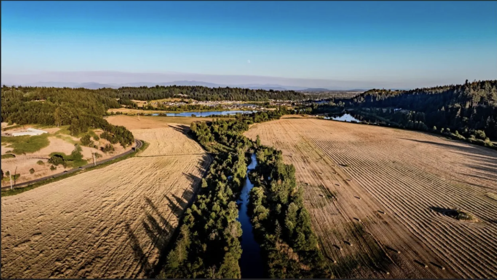
Aerial view of the Herren Crossing property — Mill Creek winding through harvested agricultural fields, Cascade foothills in the distance
177 Acres·IC/IG·Salem, Oregon

Most land marketed as data-center-ready isn't. Here's ours, measured.

A 177-acre IC/IG industrial parcel inside Salem city limits, directly adjacent to Verrus's proposed Oakline at Mill Creek campus — owner-direct, with brokerage representation through Tradition Real Estate Partners.

Three verified interconnection paths across two utilities, with a substation 477 feet off the property line. An irrigation district that confirms a path to industrial water. A zone change that's approved and recorded, in a city that already hosts Amazon, FedEx and Home Depot next door. And a buildable area we've measured rather than estimated — roughly 50 to 70 acres after fill, out of 177. That last number is the one most sites won't give you.

The three-point test — power, water, land
  • Substation 477 feet from the property edge
    PGE Barnes Substation, two transformers at 21.2 MVA each. Distribution-tier service without a multi-mile extension.
  • Transmission on-property, two utilities
    PGE 115 kV runs along Turner Rd through the parcel to Bethel Substation. PacifiCorp 230 kV crosses the southern boundary. Two independent utilities, not one.
  • Room for co-located generation behind the meter
    5+ MW of on-site generation with storage fits on ground that can't be built on. Oregon's Data Center Advisory Committee reports in October 2026 and is expected to push toward co-located generation requirements.
  • A district that says there's a path to industrial water
    Santiam Water Control District reports substantial volume available and a path to industrial use. Mill Creek surface water on-property. Quantity, season and terms are being documented now.
  • Inside city limits — one jurisdiction, no annexation
    City of Salem, inside the Urban Growth Boundary. No EFU, no ORS 215 county siting review, no high-value farmland restriction. Zone change CPC-ZC23-02 approved and recorded.
  • The floodplain work is already done
    2D HEC-RAS unsteady model by WEST Consultants, May 2024, FEMA-grade and calibrated to the 2012 flood. Your engineer can review it rather than build it.
Total IC/IG
177.9 ac
Lot 1 IC: 165.73 · Lot 1A IG: 12.17
Buildable After Fill
50–70 ac
Measured, not estimated
Jurisdiction
City of Salem
Inside UGB · no annexation
Zoning
IC + IG
CPC-ZC23-02 recorded
§ 01Power

Three independent paths. Two utilities.
One is 477 feet away.

Speed to energization is what decides most data center sites, and the usual killer is distance to interconnection. PGE Barnes Substation sits 477 feet from the northern property edge. PGE 115 kV transmission runs through the parcel. PacifiCorp 230 kV crosses the southern boundary. Two utilities means two queues and two negotiating positions rather than one.
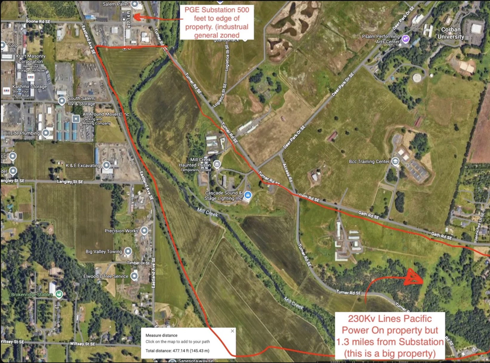
Annotated aerial map showing the 477 ft distance from PGE Barnes Substation to the northern property edge, the property outline traced in red, and the PacifiCorp 230 kV transmission line crossing the southern boundary on-property
Annotated aerial  ·  PGE Barnes Substation 477 ft from northern edge  ·  PacifiCorp 230 kV transmission on-property at southern boundary
Path 01
PGE · Distribution
Barnes Substation
13 kV
477 ft from the northern property edge. Two transformers at 21.2 MVA each. The closest feeder (Barnes-Boone) shows roughly 5–15 MW of open hosting capacity per PGE published data. This is the fastest path to first power for a phased build or a construction load.
Distance
477 ft
Capacity
10–30 MW
Path 02
PGE · Transmission
115 kV
→ Bethel
PGE 115 kV transmission (Tap207048) runs along Turner Rd through the property and terminates at Bethel Substation, a 115/230 kV switching node receiving capacity upgrades under PGE's 2024–2025 Local Transmission Plan.
Voltage
115 kV
Capacity
50–100+ MW
Path 03
PacifiCorp · Transmission
230 kV
On-Property
PacifiCorp 230 kV crosses the southern property boundary. Worth stating plainly: the line is on-property, but the nearest PacifiCorp substation is 1.3 miles away, so this path carries switching-station scope that the Barnes path does not. It's the highest-capacity option and the longest lead time of the three.
Voltage
230 kV
To Substation
1.3 mi
§ 02Water

A district with volume — and a path to industrial use.

Water kills more Pacific Northwest data center sites than power does, and most sellers can only offer municipal service. Here there are three sources on or under the property, and the irrigation district says the industrial door is open. We're documenting it now rather than claiming it.

What the district says
Santiam Water Control District reports substantial volume available and a path to industrial use. We are working with the district to document quantity, season of availability, delivery point and terms in writing. Until that letter is in hand, treat this as a strong indication rather than a secured allocation — which is how we'd want it represented to us.
What's on the property today
Mill Creek runs through the site with surface water available on-property. Certificated water rights are appurtenant to the ground; specific rights and district patron status are pending title confirmation. The easement to the Mill Creek point of diversion is retainable across any sold parcel.
Municipal service
The site is inside Salem city limits and inside the Urban Growth Boundary, so municipal water and sewer service are available through standard city extension rather than annexation. A water booster is among the off-site improvements identified for the corridor.
Why three sources matter
A closed-loop or air-cooled campus may never need the district water at all. An evaporative design does. Having municipal service, on-property surface water, and a district path to industrial volume means the cooling architecture drives the water strategy rather than the other way around.
§ 03Land

177 acres. 50 to 70 you can build on.

Here is the number most listings bury. Roughly 117 acres of the parcel sit in the Mill Creek floodplain — FEMA Zone AE plus regulatory floodway. After fill and cut/fill balancing, the realistic developable pad is 50 to 70 acres. We'd rather you know that on the first page than find it in week six of diligence.

What that supports
A 50–70 acre pad is a real campus footprint with room for substation yard, generation, and phasing. For scale: Verrus's proposed first phase next door is 600,000 square feet. This is not a hyperscale land bank, and it isn't priced or pitched as one.
What the floodplain acreage is good for
Ground that can't carry a building can carry generation. Elevated racking 8–12 ft above grade displaces zero flood storage volume, satisfying the NFIP "no net loss" framework and Salem Ordinance No. 6-25 without fill. That's where 5+ MW of behind-the-meter solar and storage goes — turning the constraint into the co-located generation that Oregon policy is moving toward requiring.
The hydraulic modeling is done
WEST Consultants (Erik McCarthy, PE, CFM and Hans Hadley, PE, CFM) completed a 2D HEC-RAS unsteady evaluation in May 2024. Results: −0.01 ft upstream BFE impact, no impact downstream at Turner Rd, and a localized +1.50 ft rise contained inside the property boundary that can be optimized through cut/fill balance. The model and topography deliverables go to any qualified counterparty under MNDA — worth $100K+ and 6–12 months against starting from scratch.
§ 04The Community Case

The 117 acres you can't build on is how this project gets approved.

Oregon data centers are running into rooms full of angry people. The parcel next door drew a six-hour hearing and a moratorium process. The constraint on this site is also the answer to that problem: 117 acres of Mill Creek frontage that can't carry a building can carry a park — and a campus that arrives with public benefit attached is a campus that gets its approvals.

A river park, already designed
Master planning work on the wider 388 acres contemplates a large Mill Creek river park with trails, sports fields, restored riparian corridor and an interpretive center honoring the Kalapuya. The design work exists. The floodplain acreage that limits the building pad is exactly the ground it sits on — so the amenity costs a data center nothing in developable area.
Why a site selector should care
Entitlement risk is schedule risk, and schedule risk is the most expensive thing in a data center pro forma. A project that offers Salem a public river park, restored creek frontage and permanent open space enters the hearing room with something to give rather than something to defend. That is worth more than a few acres of pad.
It isn't an isolated industrial box
The 177 IC/IG acres sit inside a 388-acre assemblage under single ownership that also carries 90 acres of residential and roughly 120 acres of mixed-use zoning. A campus here lands inside a planned community with housing, parks and services around it — not stranded against farmland. For a buyer who wants the workforce-housing and community-investment story, the adjacent ground is available in the same transaction.
Generation and park on the same ground
Elevated racking 8–12 ft above grade coexists with grazing, pollinator habitat and public trails beneath it. The behind-the-meter generation described in § 03 and the park described here are not competing uses of the floodplain — they're the same acres doing both jobs.
§ 05Diligence

The questions a site selector asks first.

Direct answers, sourced to the record. Where an answer is incomplete, it's flagged here rather than buried.

Are data centers actually permitted?
Zone change CPC-ZC23-02 is approved, final and recorded — mylars signed. The site carries Industrial Commercial and Industrial General zoning inside the Salem UGB, with data center use permitted subject to standard site plan review. Not pending, not proposed.
What's the corridor doing?
Verrus filed a land use application on 31 July 2026 for Oakline at Mill Creek — a proposed $5.1B campus, roughly 600,000 sf in phase one, on approximately 100 acres of privately held ground directly adjacent to this parcel. The application is in permitting. The regional EDC, SEDCOR, is actively matching data center prospects to the mid-Willamette Valley.
Is the parcel in an active interconnection queue?
No queue position is held by current ownership. A call to Robin Moore at PacifiCorp Generation Interconnection is recommended to verify whether any prior owner filed a request that may have lapsed. A buyer starts clean on all three paths.
How much of the 177 acres can actually be built on?
Roughly 50 to 70 acres after fill. Approximately 117 acres are in FEMA Zone AE floodplain and regulatory floodway. Full detail in § 03, and the hydraulic model is available under MNDA so your engineer can verify rather than take our word for it.
Who else is in the neighborhood?
The site abuts the 600-acre Mill Creek Corporate Center — Amazon, FedEx Ground, Home Depot RDC, Henningsen Cold Storage, PacTrust and Capstone. 1.1 miles from I-5. Corban University and the Mill Creek Urban Renewal Area adjoin.
What's the ownership and process?
Owner-direct, single ownership, with brokerage representation available through Tradition Real Estate Partners. The 177 IC/IG acres are part of a larger 388-acre assemblage under one owner, which means adjacent residential and mixed-use ground can be included or excluded to fit a buyer's program. Structure is open — sale, phased takedown, ground lease, or a joint venture with the landowner contributing land as equity.
§ 06Incentives

Where the incentive math compounds.

The site qualifies for an unusual stack of state, federal and local programs. Each one is real; the combined effect on project NPV is significant.

Oregon Strategic Investment Program (SIP)
Marion County participates in the SIP. Capital investment above approximately $25M qualifies for a 15-year property tax abatement on improvements — the single largest incentive available to a capital-intensive facility in Oregon, and directly applicable to a data center capital stack.
Salem Mill Creek Urban Renewal Area
The site adjoins the existing 650-acre Mill Creek Urban Renewal Area. URA boundary extension is a recognized path to TIF financing for the off-site infrastructure this corridor needs — Turner Rd improvements, the Mill Creek bridge, and a water booster.
Federal ITC on co-located generation
On-site generation and storage carry the base 30% Investment Tax Credit, with potential stacking through the Energy Community adder (+10%, requires census tract verification) and Domestic Content (+10%). Applies to the behind-the-meter portion of a campus, not to the data center improvements themselves.
Corridor infrastructure already in planning
Public infrastructure is being planned around this corridor — road realignment, a roundabout, and water towers. Under Oregon law a large electricity consumer pays for the grid upgrades serving its own load, so a neighbor's spend doesn't transfer. But the public road, water and sewer backbone going in next door is the same backbone this site needs, arriving years earlier than it otherwise would have.
§ 07What We're Looking For

A counterparty who knows what they're looking at.

The entitlement is done, the hydraulic work is done, and the utility picture is verified. We're looking for an operator, developer, site selector or strategic buyer who can answer the questions below — and then execute.

01
Given three paths and two utilities, which do you energize to first — the 477-ft distribution tap for speed, or transmission for scale?
02
Does a 50–70 acre pad with 5+ MW of behind-the-meter generation fit your deployment model, or do you need a footprint this site can't give you?
03
What cooling architecture are you building to — and does that make the district water path decisive or irrelevant?
04
Sale, ground lease, phased takedown, or a JV with the landowner contributing land as equity? We're open on all four.
05
Do you want the adjacent residential and mixed-use ground in the deal, or carved out? Both are available under the same ownership.
06
What's your realistic interconnection-study timeline in Oregon in 2026, and which of the three paths closes your energization window?
§ 08Deal Team

An institutional team behind a single asset.

Engineering, hydraulic modeling, land use, water rights, survey, counsel and brokerage representation — all engaged on the property and available to qualified counterparties.

Principal · Owner
Chris Blackburn
Clutch Industries
Brokerage
AJ Nash, Principal Broker · Dave Smith
Civil Engineering
Josh Wells, PE
Westech Engineering
Hydraulic · Floodplain
Erik McCarthy, PE, CFM · Hans Hadley, PE, CFM
WEST Consultants
Land Use Planning
Britany Randall
Brand Land Use
Water Rights
Grant McGill
McGill Water Rights
Survey
Brad & Greg
Barker Surveying
Counsel
Sebastian Hammond · Elia Popovich
Clutch Industries (in-house) · Oregon Law Group
§ 09Contact

Two ways to engage. Both lead to the same deal.

Owner-direct or through brokerage representation — your choice. Either path opens the full data room under MNDA: title, surveys, the WEST Consultants HEC-RAS model, zoning approval, utility and transmission documentation, water district correspondence, and SEDCOR materials. A broker bonus is available to the broker who brings the buyer.

Owner-Direct
Chris Blackburn
ChrisB@clutchindustries.com
503-551-7481
Principal · Clutch Industries
Brokerage Representation